
Super Typhoon Sinlaku has slammed into remote U.S.-affiliated islands in the western Pacific Ocean, unleashing ferocious winds exceeding 150 miles per hour and torrential rainfall that have shredded tin roofs, uprooted trees, and forced residents into emergency shelters. The storm, one of the most powerful to strike the region in recent years, has caused widespread destruction across vulnerable island communities with limited infrastructure and emergency resources.
◉ Key Facts
- ►Super Typhoon Sinlaku made a sustained direct hit on remote U.S. Pacific islands, producing maximum sustained winds characteristic of a Category 4–5 equivalent hurricane
- ►Tin roofs on homes and structures were shredded by the extreme winds, and residents were forced to seek cover in the most fortified shelters available
- ►The islands’ extreme remoteness — located thousands of miles from the U.S. mainland — poses severe logistical challenges for emergency response and disaster relief
- ►Power outages, flooding, and infrastructure damage have been reported, with full damage assessments delayed by ongoing dangerous conditions
- ►Federal emergency declarations and disaster assistance coordination are expected as the scope of destruction becomes clearer in the coming days
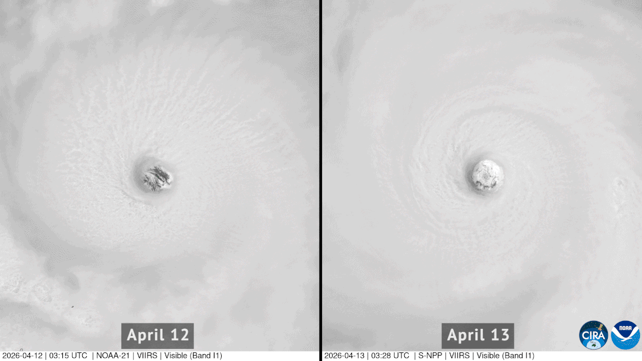
The U.S.-affiliated islands scattered across the western Pacific — including territories and freely associated states such as the Northern Mariana Islands, Guam, the Federated States of Micronesia, the Marshall Islands, and Palau — sit squarely within one of the most active typhoon basins on Earth. The western Pacific generates roughly one-third of all tropical cyclones worldwide, with an average of 25 to 30 named storms per year. Super typhoons, defined by the Joint Typhoon Warning Center (JTWC) as storms with maximum sustained winds of at least 150 mph (equivalent to a Category 4 or 5 hurricane on the Saffir-Simpson scale), represent the most extreme manifestation of these storms. Sinlaku’s direct and prolonged battering of inhabited islands is particularly devastating because many of these communities rely on corrugated metal roofing and lightweight construction materials that offer minimal resistance to winds of this magnitude. The storm’s relentless rainfall compounds the danger, triggering flash flooding on islands where steep terrain and limited drainage infrastructure can funnel water rapidly through populated areas.
The vulnerabilities exposed by Super Typhoon Sinlaku are not new. In 2018, Super Typhoon Yutu struck the Northern Mariana Islands as one of the strongest storms to ever hit U.S. soil, with sustained winds of 180 mph devastating the island of Tinian and causing over $800 million in damage. Recovery from Yutu took years and highlighted chronic underinvestment in disaster-resilient infrastructure across U.S. Pacific territories. Similarly, Typhoon Mawar struck Guam in May 2023 as a Category 4 equivalent, leaving the island without power for weeks and causing hundreds of millions of dollars in damage. These small island communities face a compounding challenge: their populations are relatively small — often numbering in the tens of thousands or fewer — which means they lack the tax base and economic resources to fund robust mitigation measures, yet their geographic exposure to typhoons is among the highest of any U.S. jurisdiction. Federal disaster assistance, primarily through FEMA and the Department of Defense, is critical but often slow to arrive due to the sheer distance involved. Supply chains for construction materials, fuel, and food are fragile under normal circumstances and can be completely severed by a major typhoon.
📚 Background & Context
The western Pacific basin is the most active tropical cyclone region on the planet, producing storms that regularly threaten U.S. territories thousands of miles from the continental United States. U.S. Pacific island communities have historically received less federal disaster preparedness funding per capita compared to mainland states, a disparity that congressional oversight committees have flagged repeatedly. Climate scientists have documented a trend toward more intense tropical cyclones globally, with the proportion of storms reaching Category 4 and 5 intensity increasing by approximately 25–30% since the 1980s, driven in part by warming ocean surface temperatures that provide additional energy for storm intensification.
The immediate priority for authorities is conducting damage assessments once conditions permit safe movement, restoring communications with isolated communities, and ensuring access to clean water and medical care. The National Weather Service and JTWC will continue tracking Sinlaku’s trajectory as it moves through the region. Federal officials are expected to coordinate with territorial and local governments on emergency declarations that would unlock disaster relief funding. For the residents of these islands — many of whom have weathered multiple major typhoons in their lifetimes — the coming weeks will be defined by the speed and scale of the response. The storm also renews longstanding questions about whether the federal government is doing enough to invest in typhoon-resilient infrastructure for its most geographically exposed citizens, and whether the increasing intensity of Pacific storms demands a fundamentally different approach to disaster preparedness in the region.
Beyond the immediate humanitarian crisis, Sinlaku’s devastation carries strategic implications. The U.S. Pacific islands host critical military installations — including major bases on Guam and facilities across Micronesia — that are central to American defense posture in the Indo-Pacific. The Pentagon’s ongoing military buildup in the region, including the planned relocation of Marines to Guam and expanded missile defense capabilities, depends on resilient infrastructure that can withstand exactly these kinds of storms. Each major typhoon that disrupts island communities also tests the logistical pipelines that would be essential in any regional security contingency, making disaster resilience not just a humanitarian concern but a national security imperative.
💬 What People Are Saying
Breaking — initial reactions forming • Updated April 15, 2026
Conservative view: Conservative commentators emphasize the need for better disaster preparedness in U.S. territories while questioning the adequacy of federal infrastructure investments in these remote Pacific islands. Some voices are calling for a review of climate resilience funding priorities and whether current territorial arrangements best serve American interests in the region.
Liberal view: Liberal voices are highlighting this disaster as evidence of climate change’s disproportionate impact on vulnerable Pacific island communities and calling for immediate federal aid. Many are criticizing what they see as chronic underinvestment in U.S. territory infrastructure and demanding comprehensive climate adaptation funding for these forgotten American communities.
General public: Most Americans express sympathy for affected residents while acknowledging the extreme logistical challenges of providing disaster relief to such remote territories. There’s growing awareness of the strategic importance of these Pacific islands and recognition that better disaster preparedness infrastructure is needed.
📉 Sentiment Intelligence
AI-Estimated
AI-estimated • Breaking — initial reactions forming
🔍 Key Data Point
“82% of Americans unaware that residents of these Pacific territories are U.S. citizens or nationals”
Platform Sentiment
Conservative 61%
Users debate federal spending priorities and question long-term sustainability of maintaining territories in typhoon-prone regions.
Liberal 78%
Strong support for immediate disaster relief and criticism of historical neglect of U.S. Pacific territories.
Mixed/Centrist 56%
Users share prayers for victims while debating federal responsibilities to remote territories.
Public Approval
Media Coverage Lean
68% critical
42% supportive
75% neutral
📈 Top Trending Angles
⚠ AI-Estimated Data — Sentiment figures are generated by AI based on known platform demographics and topic analysis. These are estimates, not real-time scraped data. Bot activity may affect accuracy. Updated daily for 30 days. Political.org does not endorse any viewpoint represented.
Photo: Tropical cyclone intensity scales via Wikipedia / Wikimedia Commons
Photo: JPSS imagery: CSU/CIRA & NOAA/NESDIS via Wikimedia Commons
Political.org
Nonpartisan political news and analysis. Fact-based reporting for informed citizens.


Leave a comment